SNOW MON!?

But, indeed the above atmospheric "model" sounding for KFYV, Fayetteville's Drake Field, is depicting snow by Midnight of Monday. The system that is just now pushing into the Pacific Northwest is packing quite a punch. Part of this looks become detached from the Jetstream and slowly meander through our area late Sunday night and into Monday, promising copious amounts of rain. As the center of the parent developing Low pressure system moves to our east late Monday, cold air will funnel in. In the diagram above this cold air is advertised through 700mb (approx. 10'000 feet). This is a sufficient depth for snow. *Note the NNW wind. Just up above this layer through about 500mb, (approx. 18,000') the wind is out of the ESE. This is an overunning situation of moist air in a below freezing layer, once again... snow! Will this pan out? ...possibly so.
All year, for the most part we've seen the cold air filter in after the precip. has ended. This one seems to be trending cold, with lingering precipiatiation! Be sure to catch updates on this impending soaker / snow-maker through the weekend.
Posted by Ted Zarras at 4:30 PM
0 comments

Weekend Changes......Snow Monday?

A ridge of high pressure aloft will dominate our pattern over the next several days, unfortunately, that won't last forever as winter returns for Monday! You can see the ridge pictured above. This is what we call a very "amplified" pattern.
The ridge will hold through Sunday, keeping temperatures above average.
All good things must come to an end though. Here's the trough digging south for Sunday. Look at the cold air to the northwest that's set to come through for Monday.


There's the potential for rain to change over to snow by Monday afternoon, so we'll be monitoring that closely.
Posted by Drew Michaels at 2:57 PM
0 comments
THURSDAY WARM UP...

A warm front will be sweeping across the area today and will bring warm temperatures. Southeast Oklahoma and Southwest Arkansas could experience afternoon highs in the upper 60s! If you are unable to get outdoors today, don't worry about it. Temperatures will continue to be warm all the way through the weekend. A cold front arrives Sunday night and provides a good chance for showers and thunderstorms. Some of those storms could be strong, so keep checking the weather blog for the latest updates about the severe weather possibilities.

Posted by Patrick Crawford at 6:23 AM
0 comments
Countdown to Spring........

Even though Spring is several weeks away, the upcoming weather may have you jumping seasons! The upper level pattern is starting to become very amplified; look at the monster ridge that's forecast to move over the plains. This will allow our temperatures to remain above average! This ridge will keep the real cold air at bay to the north; however, with an amplified pattern, you can eventually count on a cold snap to follow the warmth!
The 850 mb temperatures seen below really show the warming trend throughout the weekend. This level of the atmosphere can really show trends of warming and cooling.

Posted by Drew Michaels at 7:55 PM
0 comments
MUCH COLDER TODAY!
 The cold front that moved through the area Monday night and Tuesday morning not only gave us very strong winds, but it also caused a major change in our temperatures. Here is a look at the 24 hour temperature change for our morning lows. So this compares where we were Monday morning to where we were Tuesday morning. It's a great tool to show the progress and strength of cold fronts and warm fronts across the U.S. over a 24 hour period.
Posted by Patrick Crawford at 5:39 AM
0 comments
Buried To The Roof...

Posted by Ted Zarras at 3:49 PM
0 comments
NOW THAT'S A LOW!

There are actually two in the shot... both are quite impressive! The "main" one and closest to the States, (big counter clockwise spinning mass of clouds that pushes into Northern California at end of loop) was kicking up waves to 30 feet! White out conditions hit the Sierra Mountains and up to a foot and a half of snow fell as this pushed in-land. The storm lost much of its "Hurricane-like" shape through Sunday, but a re-development just north of us will be looking impressive too! Parts of the northern plains and Great Lakes are under the gun for Snow, Sleet and generally adverse driving conditions. We'll get some wind along with a few showers and possibly a rumble of thunder. In fact, wind gusts already have been high, with Fayetteville reporting gusts up to 33 mph! As this system pushes eastward expect a cold wind out of the North to usher in, reminding us that the calendar still says February.
Posted by Ted Zarras at 9:46 AM
0 comments
BIG CHANGES THIS WEEK!

The Jetstream has been very active over the past several weeks and the week ahead is no exception to the trend! A powerful Low and associated upper level trough has pushed into the country from the west. On Saturday this surface Low looked like a Hurricane while spinning in the Pacific just off the California coast. The storm has since lost its shape but a good bit of Jetstream energy is helping to develop a new surface Low just east of the Rockies. This too will wrap up a good bit and gain strength. The biggest effect it will have on us will be a significant temperature drop as it drags a cold front through late Monday along with a bunch of wind. Prior to this we'll be above average with widespread 60s, but by Tuesday we'll be back in Winter with chilly highs in the upper 30s to middle 40s, some five to ten degrees below seasonal averages. Couple these temps with gusts perhaps as high as 30 to 40 mph and it will be feeling like upper 20s and 30s! Friday looks to bring in another trough to our area and the likelihood of some rain. Late Sunday brings in yet a third system, which may dig far enough to the south to tap into abundant moisture. Should this be the case and a great enough temperature contrast is present, we may be contending with a round of strong to severe t-storms. We'll be monitoring this threat through the week.
Posted by Ted Zarras at 9:26 PM
0 comments
La Nina
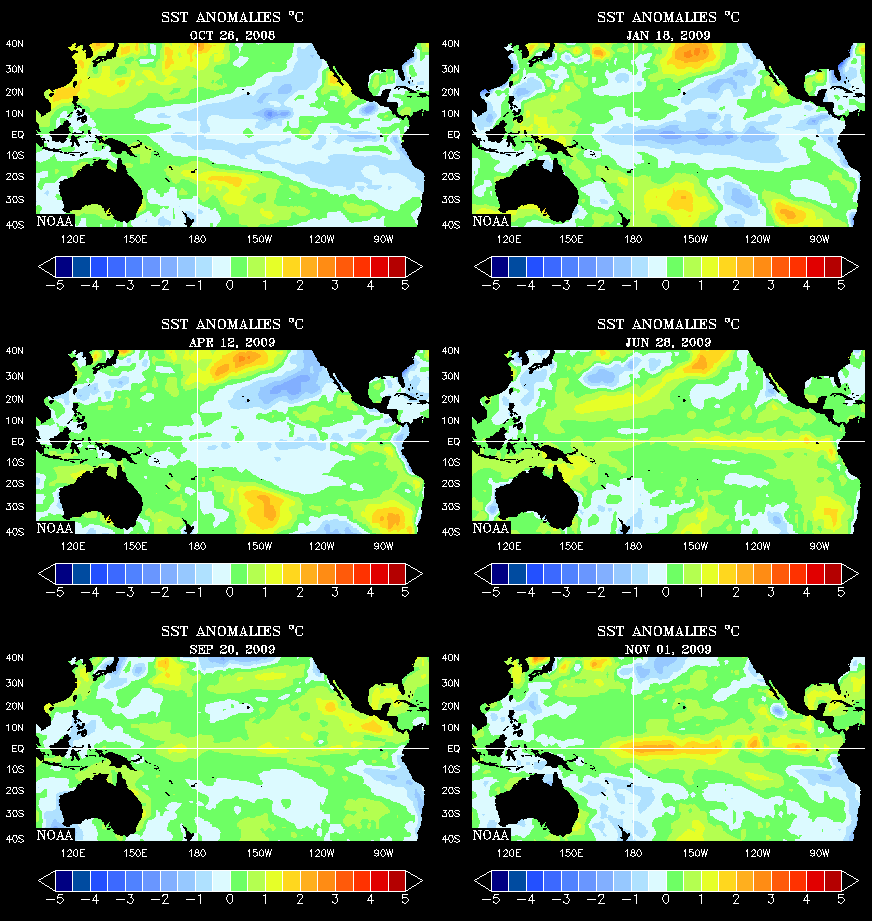
Precipitation-wise, we tend to be a little below average under such conditions. January was very dry. February, thanks to the rain of Feb. 16-17, has been wet. Slight chances of rain are in the extended forecast now, but we're not looking at any gully-washers! Temperature-wise, La Nina conditions tend to keep us a little warmer than average. We have dodged a few potentially devastating ice events... so; we'll see what the rest of the winter has in store.
Posted by Ted Zarras at 3:34 PM
0 comments
Libration

We missed out on seeing the lunar eclipse last night due to the clouds, but here's an interesting fact about viewing the visible moon and a very cool picture to go with it! Through a process known as Libration it is possible to "view" more than 50% of the visible surface which is tidally locked in a fixed position relative to Earth.
There are three types of libration:
Libration in longitude is a consequence of the Moon's orbit around Earth being somewhat eccentric, so that the Moon's rotation sometimes leads and sometimes lags its orbital position.
Libration in latitude is a consequence of the Moon's axis of rotation being slightly inclined to the normal to the plane of its orbit around Earth. Its origin is analogous to the way in which the seasons arise from Earth's revolution about the Sun.
Diurnal libration is a small daily oscillation due to the Earth's rotation, which carries an observer first to one side and then to the other side of the straight line joining Earth's center to the Moon's center, allowing the observer to look first around one side of the Moon and then around the other.
Posted by Ted Zarras at 5:18 PM
0 comments
SLEET NEAR HUNTSVILLE

Posted by Ted Zarras at 10:47 AM
0 comments
FREEZING RAIN UPDATE...
 Here is an update on the freezing rain chances for Thursday. The blue line represents a 10% chance for freezing rain. Most of NE OK, NW AR and SW MO are included in the 10% probability for freezing rain. Temperatures look to climb above freezing (32°F) for the afternoon. So the freezing rain chances will be with us early Thursday morning and after sunset Thursday evening. We will have updates all day on the slight winter weather possibilities, so keep on checking the best local weather blog for the very latest weather information.
Posted by Patrick Crawford at 11:57 PM
0 comments
Thursday's Winter Weather Update


The cold air has really taken a slow trek throughout the Ozarks; unfortunately, the computer model guidance has a real tough time with a shallow arctic air mass, and that leaves uncertainty in the forecast. We're expecting winter weather for Thursday; however, some places like the River Valley and south won't deal with it until Friday morning. Look at the timelines above for more detail.
The greatest areas for ice will stay across McDonald, Benton, Carroll, and Delaware counties. Here's what we're expecting for total ice accumulations.

Remember, Thursday afternoon should be fine with temperatures warming above freezing; the ice totals are more for Thursday morning and evening. Be very careful of bridges and overpasses!
Posted by Drew Michaels at 4:46 PM
0 comments
Total Lunar Eclipse Tonight


Posted by Brian Emfinger at 8:51 AM
0 comments
Freezing Rain Potential.....

A classic overrunning situation will take shape late Wednesday as our 850 mb winds flow out of the southwest. Temperatures will warm aloft, but that won't be the case at the surface. The warm air will overrun the cold with this system; we're expecting surface temperatures to hover right around freezing across NE OK and NW AR, and that's where problems will occur.

Light ice accumulations could total as much as a tenth of an inch across NE OK and NW AR, which could cause problems on roadways. The River Valley may see some freezing rain on Thursday, but temperatures may stay just above freezing to avoid accumulating ice. We'll be watching it very closely over the next 24 hours.
Posted by Drew Michaels at 7:57 PM
0 comments
LeFlore County Severe Weather Training Tonight
This is a great opportunity for you to learn more about: storm structure, mechanics, chasing, and severe weather reporting. Please let us know if you become trained; we always welcome your reports!
Posted by Drew Michaels at 9:53 AM
0 comments
COLD AIR SPILLS IN

Posted by Ted Zarras at 3:23 PM
0 comments
TODAY'S WEATHER
 High pressure will be in control of our weather today. That means we will have sunshine early in the day, but a cold front looks to clip our northern counties tonight. When the cold front arrives tonight we can't rule out a few snow flurries across NE OK and NW AR. Accumulations will be very minimal and we are not looking at any major travel issues Tuesday morning. Warmer air arrives Tuesday afternoon and therefore we are going to experience some very nice weather Tuesday afternoon. Enjoy!
Posted by Patrick Crawford at 3:34 AM
0 comments
ABUNDANT RAIN!


January was light in the rainfall department across our towns... definitely not the case for February! We look to end the month well above average. Here's a fleeting thought in the "what if?" category for all of you snow fans: At a stock ten to one ratio of snow to rain, that is ten inches of snow melting down to one inch of rain, some of us would have had nearly three feet! ;)
Posted by Ted Zarras at 7:24 PM
0 comments
Some Flooding Pictures
The picture on the left is of a small tributary of the Little Mulberry River overflowing a low water bridge late Saturday night and the Little Mulberry River this morning (Sunday) with some of the road washed away. Both pictures were taken from about 4 miles southeast of Pettigrew (Southern Madison County)


While making the short hike to the High Bank Twins Waterfall I saw this tree that had apparently been blown up by lightning. I had checked the waterfall last Saturday (Feb 9) and this had not happened yet so it must have happened sometime Saturday Night (Feb 16)


You can view many more pictures - HERE
Posted by Brian Emfinger at 4:24 PM
0 comments
FLOOD SAFETY

Posted by Ted Zarras at 5:33 PM
0 comments
HEAVY RAIN ...then some SNOW!?

As an upper level low meanders at a slow pace through our area, showers with imbedded thunderstorms will blossom. Some storms in SE OK and SW AR may be on the strong side, containing gusty winds and perhaps some small hail.

This atmospheric sounding for the noon hour on Sunday in Fayetteville is showing snow! The temperature is very close to freezing at the surface, but just above the entire atmosphere is below. Higher terrain will likely see wintry precipitation first and a ground covering can't be ruled out in a few spots. As the storm pulls away from our area cold air will continue to filter in on the back side of the Low. This "wrap around" precipitation will not be as heavy as the pre-frontal stuff, but it still may zap a few towns back into a winter like feel for a few hours. We'll be monitoring developments closely and will alert you both on air and on the web if any travel concerns arise.
Posted by Ted Zarras at 4:17 PM
0 comments
Why So Windy??????


I saw this yesterday and knew right away that we would have a very windy day. The winds at 850 mb (5,000 ft) were cranking out of the southwest this afternoon. The models had the winds between 50 and 60 knots at 850; that translated into a lot of mixing to the surface.
Unfortunately, the warming trend has come to an end, and now colder air works back toward the area tonight. Fortunately, the models are very warm with the temperatures aloft, so this weekend's storm system will most likely translate into heavy rainfall. There will be a chance for a wintry mix of Sunday, but the moisture starts to move out just as the atmosphere cools enough to support snow. We'll keep our eyes on it.
Posted by Drew Michaels at 4:48 PM
0 comments
HEAVY RAIN POSSIBLE THIS WEEKEND
 We have a good chance for some rain showers this weekend. Here is a look at the GFS weather model for Saturday night and Sunday morning. Notice the heavy showers over the entire viewing area. We will have warm temperatures aloft and even our temperatures at the surface should stay above freezing. Now we could be dealing with some areas of freezing rain for far NE OK and NW AR, but as we look at the surface temperatures at this exact time we can see that above freezing temperatures will be taking place over a majority of the region. Also, notice how strong the showers will be, but we are not forecasting thunderstorms. This precipitation will not have a lot of available energy, but it will have plenty of moisture to work with so we might be dealing with possible flooding. It's something that we will be watching very closely in the 40/29 SuperDoppler Weather Center.
Posted by Patrick Crawford at 6:41 AM
0 comments
Today's Snow Flurries

Well, what do you get when you combine some lingering moisture, and extremely cold temperatures aloft? Unfortunately it's not a joke, but it does give us an answer to the light snow from today. The clouds didn't clear like the models had anticipated, and with the strong northwesterly winds aloft, the combination of cold air and moisture was enough to squeeze out some fine light snow flakes.
Look at the picture above. This is a depiction of relative humidity around 1,500 feet aloft. The moisture was just deep enough to produce the light snow. Moisture around 5,000 feet really wasn't present, so you had a very shallow area of low clouds, but that proved to be enough today.
By the way, the best snow making typically occurs around 10,000 feet above our heads; maybe Friday will lead to better snowfall.
Posted by Drew Michaels at 4:17 PM
0 comments
Ouachita's Flooding


The top picture is of the Petit Jean River flooding over a rural road and bridge just off Hwy 71 (near the rest area) and the bottom picture is of the Fourche La Fave River at Boles flooding high over a county road and bridge.


The top picture is of Mill Creek at Y City and the bottom picture is of a scenic waterfall along the Ouachita National Recreational Trail in Northern Polk county (just off Hwy 71)
You can see more pictures - HERE
Posted by Brian Emfinger at 12:13 PM
0 comments
SEVERE WEATHER UPDATE
 The system that gave us the strong showers and storms late last night and early this morning is now pushing off the the east and northeast. It will continue that path for the rest of the morning and we will get a gradual clearing trend for the afternoon. High pressure will build to our north and allow the cold air to push into the region. Afternoon highs will be chilly for the afternoon, but warmer weather will be here for Wednesday and Thursday.
Posted by Patrick Crawford at 1:02 AM
0 comments
12:30 Update


Strong to severe showers and storms continue to develop along a frontal boundary throughout eastern Oklahoma and western Arkansas. The strongest storms will be capable of producing hail to the size of quarters and gusty winds around 50 mph. The storms should continue to feed on the strength of the low level jet through 3 a.m. especially south of I-40.
These storms are elevated in nature, so the tornado threat is low for tonight.
Posted by Drew Michaels at 10:11 PM
0 comments
11 P.M. Update
Temperatures are right around freezing across Delaware, Benton, Washington, and Carroll counties, so freezing rain is still a concern. It does look like the heavy rainfall will push south of Benton and Delaware counties after midnight. Watch out for slick bridges and overpasses.
Posted by Drew Michaels at 8:54 PM
0 comments
Storm Pics

 We have had several strong thunderstorms move across our area tonight. And while we have had several severe thunderstorm warnings, the only severe report we have so far was of golfball size hail and winds to 60 mph down in McCurtain County (7 miles north of Broken Bow). The two pictures above were taken from Altus looking directly towards a storm that was moving over Paris, AR.
Posted by Brian Emfinger at 8:08 PM
0 comments
9:00 P.M. Update
The showers and stroms will pose three issues: small pea size hail, gusty winds to 40mph, and brief heavy rainfall. The severe thunderstorm watch is out until 2 a.m. across SE OK; however, I feel most of the severe weather will remain across northern Texas where the instability is greatest. More updates to come!
Posted by Drew Michaels at 6:37 PM
0 comments
7:00 P.M. Ice Update
Bridges and overpasses will be the first to show icing. Be very careful if you are planning to travel across Benton and Delaware counties this evening.
Posted by Drew Michaels at 4:19 PM
0 comments
Monday's Freezing Rain Potential
A wave of low pressure will march across the area on Monday, creating light areas of precipitation; however, temperatures across NE OK and NW AR will remain below freezing during the morning, so light areas of freezing rain and freezing drizzle will be possible.
Ice accumulations up to a tenth of an inch will be possible. Be especially careful of the bridges and overpasses, since they will be the first to ice over. During the afternoon, temperatures may warm just above freezing, but more evening freezing rain could develop.
The River Valley and points south should remain above freezing; no freezing rain is anticipated!
Posted by Drew Michaels at 8:27 PM
0 comments
STORM SPOTTER TRAINING

FYI...
The Clinton and Atkins tornado damage was viewed via airplane today and as suggested, was deemed to be from the same tornadic supercell, with one continuous damage path stretching for over 120 miles!
Here's a link to the Storm Spotter Training Schedule for 2008.
Posted by Ted Zarras at 10:24 PM
0 comments
Clinton Tornado Update

The Tornado(s) that tracked through Atkins and Mountain home may have been one long-lived tornado that recycled to various strengths along a pathway stretching well over 100 miles! Damage was evaluated today by Quick Response team member, Alan Gerrard, who is also the Meteorologist in charge of the NWS office in Jackson. He was joined by John Robinson, the Warning Coordination Meteorologist and Renee Fair, the Meteorologist in charge, both from the NWS office of Little Rock. The communities of Atkins, Clinton, Mountain View and Highland AR were viewed today. Subsequently, the initial rating of EF3 damage attributed to the tornado has now been upgraded to EF4 damage. The EF4 category of the "Enhanced Fujita" damage scale correlates with wind speeds of 168-199 mph!
An aerial flight of the path is scheduled for tomorrow. This will hopefully confirm whether one or several tornadoes were responsible for the damage.
Posted by Ted Zarras at 3:07 PM
0 comments